
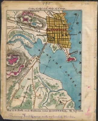
Alexandria›The U.S. forts and batteries near Alexandria Va. Sept 1862 : showing Fort Lyon with extended works.
- Publication:
- US, Civil War Maps, 1861-1865
- Region:
- Virginia
- Location:
- Alexandria
- Title:
- The U.S. forts and batteries near Alexandria Va. Sept 1862 : showing Fort Lyon with extended works.
- Source:
- Virginia Historical Society
- Description:
- Shows the locations of Union fortifications surrounding Alexandria, Va., including forts Lyon and Ellsworth in Fairfax County. The locations of Hunting Creek and the Potomac River are also indicated.
- Conflict Period:
- US Civil War
View the actual high resolution document.
About US, Civil War Maps, 1861-1865
Maps, charts, and atlases depicting battles, troop positions and movements, engagements, and fortifications during the Civil War, 1861-1865.
Source Information
Forces War Records, US, Civil War Maps, 1861-1865 (https://nz.forceswarrecords.com/document/279588949/the-us-forts-and-batteries-near-alexandria-va-sept-1862-showing-fort-lyon-with-extended-works-page-1 : accessed 3/05/2024), database and images, https://nz.forceswarrecords.com/document/279588949/the-us-forts-and-batteries-near-alexandria-va-sept-1862-showing-fort-lyon-with-extended-works-page-1
- Publication Title
- US, Civil War Maps, 1861-1865
- Total Records
- 1,933Complete: 100%
- Content Source
Fold3
- Published on Forces War Records
- 20 May 2010
- Last Updated
- 18 November 2011
Related Records
Related Publications
- US, The Horse Soldier Civil War Collection of Military Artifacts, 1861-1865
- Civil War Stories
- US, General Court Martial of Gen. George A. Custer, 1867
- US, Subject File of the Confederate States Navy, 1861-1865
- US, Official Records of the Union and Confederate Navies, 1861-1865
- US, Maine, Burial Records of the Togus National Home for Disabled Veterans, 1874-1938
- US, Weekly Returns of Enlistments at Naval Rendezvous ("Enlistment Rendezvous") Jan. 6, 1855-Aug. 8, 1891
- US, New Hampshire, Revolutionary War Records, 1675-1835
- US, Washington State Military Records, 1855-1950
- US, Adjutant General Military Records, 1631-1976
- See all publications