
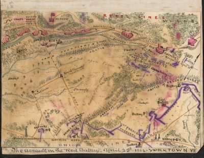
Yorktown›The assault on the "Red Battery," April 25th, 1862 Yorktown, Va..
- Publication:
- US, Civil War Maps, 1861-1865
- Region:
- Virginia
- Location:
- Yorktown
- Title:
- The assault on the "Red Battery," April 25th, 1862 Yorktown, Va..
- Source:
- Virginia Historical Society
- Description:
- Shows the area between the Warwick River to the west and the Warwick Road to the east as McClellan's forces attacked Confederate batteries on the Peninsula south of Yorktown, Va.
- Conflict Period:
- US Civil War
View the actual high resolution document.
About US, Civil War Maps, 1861-1865
Maps, charts, and atlases depicting battles, troop positions and movements, engagements, and fortifications during the Civil War, 1861-1865.
Source Information
Forces War Records, US, Civil War Maps, 1861-1865 (https://nz.forceswarrecords.com/document/279588920/the-assault-on-the-red-battery-april-25th-1862-yorktown-va-page-1-us-civil-war-maps-1861-1865 : accessed 29/04/2024), database and images, https://nz.forceswarrecords.com/document/279588920/the-assault-on-the-red-battery-april-25th-1862-yorktown-va-page-1-us-civil-war-maps-1861-1865
- Publication Title
- US, Civil War Maps, 1861-1865
- Total Records
- 1,933Complete: 100%
- Content Source
Fold3
- Published on Forces War Records
- 20 May 2010
- Last Updated
- 18 November 2011
Related Records
Related Publications
- US, The Horse Soldier Civil War Collection of Military Artifacts, 1861-1865
- Civil War Stories
- US, General Court Martial of Gen. George A. Custer, 1867
- US, Subject File of the Confederate States Navy, 1861-1865
- US, Official Records of the Union and Confederate Navies, 1861-1865
- US, Maine, Burial Records of the Togus National Home for Disabled Veterans, 1874-1938
- US, Weekly Returns of Enlistments at Naval Rendezvous ("Enlistment Rendezvous") Jan. 6, 1855-Aug. 8, 1891
- US, New Hampshire, Revolutionary War Records, 1675-1835
- US, Washington State Military Records, 1855-1950
- US, Adjutant General Military Records, 1631-1976
- See all publications